Six Deepest Points on Earth

The Dead Sea, Jordan

Is it possible for some parts of the world to exist below sea level? The answer is yes. Sea level is the average level of the Earth’s surface which is used as a parameter to measure the planet’s elevation. There are multiple locations that have a negative attitude when compared to sea level. In the post below, you will find out about six such locations that are indeed unique. 

The Dead Sea – Israel, Jordan 

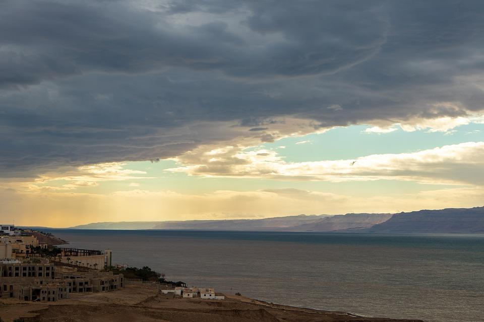
The lowest point or the deepest place on Earth is the Dead Sea in the Jordan Rift Valley, bordered by Isreal on the west and Jordan on the east. It is a famous tourist destination where people visit to explore the uniqueness of this sea.

The known depth of this point compared to sea level is almost 1,355 feet (413 meters) however, the parameter can be complicated due to various weather conditions. It depends upon the rate of precipitation and the level of water evaporation from the sea. In case of a drought, when there is limited rainfall and evaporation rate is high, the depth of this lowest point can reach its maximum which is 1,355 feet below sea level. After the rainfall, the depth can be decreased by a few feet.

The distinguishing feature of this coast is the high salt content which forms for the incredibly unique natural landscape. The high concentration of salt attracts tourists due to health reasons. It is believed that salt water can cure numerous diseases and conditions of the skin.

The reason for excessive salt concentration in this sea is the presence of salt rocks during the oceanic water. Due to higher levels of evaporation of the water from the sea, the salt rocks are exposed even at the coast. Also, these salt rocks are the reason for the formation of natural landscapes and sculptures. So tourists who visit this place not only enjoy the unique formations but also benefit from the assumed healing properties of the water from this deepest point on Earth. 

Lake Assal, Djibouti

The second-lowest point is the Lake Assal in Djibouti. An East African country located in the Horn of Africa on the Gulf of Aden. It is situated at the bottom of a crater lake which is almost 509 feet (155 meters) below sea level.

This lake is a part of the larger region known as the Afar depression which extends well into Ethiopia. It was described by National Geographic as the cruelest place on Earth due to extreme climatic conditions. Similar to most other lowest points, Lake Assal is characterized by high temperatures, desert and a volcanic landscape. 

The Turfan Depression

The third lowest point below sea level is Turfan Depression, a location in China with a depth of 505 feet (154 meters). This, however, is the average depth of the area and the exact depth varies with climatic conditions. Despite the hot and dry climate, there is a salt lake at the bottom of this depression. In the northern part of this depression is a small oasis city known as Turfan. 

Based on the archaeological research, it is believed that the area was inhabited by humans in the 10th century. Today, this is an important historical site for tourists who can enjoy the remains of the early civilization along with the evidence of the last volcanic eruption in the 12th century. It is also believed that the high level of volcanic activity over the number of years has also contributed towards the formation of this depression.

This depression also experiences the similar weather conditions as the Lake Assal. The summers are hot and dry and temperatures in the region can spike up to 104 oF. During the summers, this  deepest point in South Asia and China is always dry so is the salt water lake at the bottom of this depression. 

Qattara Depression 

Another deepest lowland is again found in the African continent. With a depression of 436 feet (133 meters) below the sea level, the Qattara Depression forms one of the lowest points in Africa. After extensive research of this region, the archeologists believe that the region was never inhabited due to the extreme weather conditions and lack of water. The average annual rainfall in the region is as low as 2.1 inch. During summers, the temperature can rise as high as 97 oF. The extensive heat and lack of rainfall results in the prevention of water basins however, the distinguishing feature despite high temperatures in the breeze which does not stop at any time of the year. Today, only a few nomads can be found in the region.  

Caspian Depression, Kazakhstan

The largest enclosed body of water in the world is the Caspian Sea which is also one of the lowest points below sea level. The shore of this depression is almost 92 feet (28 meters) below sea level. The sea strands its borders with countries of the U.S.S.R region including Azerbaijan, Turkmenistan, Russia and Iran. Unlike its name Caspian Sea, the Caspian Sea is not a sea or part of the ocean but is a salt water lake with no natural outflow. This lowland depression includes the Northern Part of the Caspian Sea. 

Danakil Valley 

Another lowland in Africa is the Danakil Valley. It is located in Ethiopia and is referred to as Danakil desert. The valley is unique because it is located at the border of the three large tectonic plates including the African plate, the Indian Plate and the Arabic Plate. This valley is considered to be one of the most dangerous places in the world. This is not only due to extreme temperature and weather conditions but also due to the poisonous landscapes. The valley is known for its constant volcanic eruptions which are accompanied with sulfurous water. Together, it forms a dangerous landscape releasing toxic fumes that too at a depth of 410 feet below sea level. 

This extremely hot and dangerous valley was not known until 1928 when a group of travelers first identified this location. This group of travelers which was led by Tullio Pastori managed to cross the valley on foot. To date, no other group of travelers have managed to accomplish this. As of now, this valley is a tourist destination but only for those courageous enough to survive in extreme conditions. It is here that you can witness the continuous eruptions of lava which have been spreading since many years. 

Conclusion 

Lands below the sea level not only have a unique landscape but also have distinct weather conditions which are much different from that on the surfaces at sea level. There are many other lowlands of Earth. Some of the most famous ones not included in this list are the Death Valley and the Salton Trough.

Famous Geysers of the World

Iceland fountain is a famous tourist destination
pixabay.com/images/id-1594853/

An Overview of Geysers

A geyser is a vertical column that periodically erupts hot water and steam. This amazing phenomenon that blasts water from beneath the surface of the Earth is a truly rare sight.

For those who are unaware of what a geyser is, it is a geological feature similar to a tube that runs deep into the Earth’s crust. This tube is often filled with water, but the heat comes from the molten rocks at the bottom of it. The molten rocks called magma heat the water in the tube to a point where the water starts boiling and turns into steam. Since the space is limited, the steam is pressurized. As a result, we can see boiling water and steam erupting from the tube called a geyser. 

There were numerous active geysers around the world. However, in the last century, we have seen a decrease in the number of them. Currently, there are only five countries in the world that have them. 

  • The United States 
  • Russia 
  • New Zealand
  • Iceland 
  • Chile 

Despite their geographical distance, there is one thing which is common in all five countries; they are all located in regions with recent volcanic activity and are near the tectonic plates. While every geyser functions in the same way, they are not all the same. Below you will find out about some of the famous geysers around the world and what makes them special. 

Geysir

Iceland is a country with numerous islands, active volcanoes and yes, geysers. The Great Geyser, also known as Geysir, is the most primitive geyser known to date. It can be dated back to around 10,000 years ago The first printed document about the geyser was recorded in 1294. Even the name geyser comes from a native word “geysa” which means hot springs.

The steam plume can fire up to eight times a day and can reach a height of more than 200 feet. The super-heated lava in the region melts the ice which is present in the region throughout the year. As a result, there is an increasing number of active geysers in the region. A critical fact about geysers is that they can become active and inactive suddenly due to changes in the geothermal activity taking place below the surface of the Earth. This was also the case with Geysir, which stopped erupting in 1932 and started again after the earthquake of 2000

Old Faithful 

Located in Yellowstone National Park , this is probably the oldest and most famous geyser on the Earth. As the name suggests, it has been continuously erupting regularly, hence it has been named faithful. The old geyser has been erupting for the past 30 years and erupts 23 times every day. But the height of eruptions is comparable to some of the other taller geysers in the world. The eruptions can reach from 100 to 180 feet in height.

Old Faithful is a classic example of a cone geyser. This type of geyser produces a constant, vertical column of water where water shoots up from its opening. 

Grand Geyser, Yellowstone National Park 

Yellowstone National Park has one of the most active geyser basins in the world. The reason is its proximity to the mid-Atlantic ridge. This means they are located at the intersection of two tectonic plates – the North American plate and the Eurasian plate. These plates are at the moment moving away from each other at a rate of three-millimeters per annum. This movement releases energy which is causing hot, molten lava to flow out. As a result, there are more active volcanoes and geysers in the region. 

Moreover, the Yellowstone National Park is on top of Yellowstone Super Volcano Caldera in northwestern Wyoming and southeastern Montana. The grand geyser is located in the southern part of the park just 160 feet north of a more frequently erupting called Strokker geyser. It is a fountain geyser and is the tallest predictable geyser known to date.  It reaches a maximum height of 200 feet. Each eruption lasts for 9 to 12 minutes after which the pool becomes dry and refilling time is 5 to 6 hours. Hence the eruption takes place 1 to 4 times a day. 

Strokkur Geyser, Iceland  

Stokkur geyser is located around 160 feet south of the Great Geyser in Iceland in the Haukadalur valley area. This area also has mud pools, fumar holes and other geysers. It is a very sensitive geothermal location. Strokkur is a native word in Iceland which means to churn. Strokkur geyser is known for its rapid eruptions which can be seen after every five to ten minutes.

Each eruption lasts for approximately two minutes. The usual height of the geyser is around 50 feet. However, when the first eruptions were noticed in 1789, they were as high as approximately 200 feet. Later in 1896, the geyser became inactive due to an earthquake which blocked the steam flow. It became active again through human efforts in 1963 when the geyser committee of Iceland advised the locals and the blockage was removed. It has been active ever since. It is again one of the very few reliable geysers which have been erupting very regularly. 

Waimangu Geyser, New Zealand 

Let’s not forget the Waimangu Geyser which was the tallest geyser in the world. The eruptions from this geyser have reached a height of around 1,500 feet above the ground level. Such was the power of Waimangu geyser.

The first eruptions were noticed as early as in 1901. The cycle of the geyser was around 36 hours. These eruptions lasted for five to six hours and were a popular tourist destination. However, in 1904 the geyser started to lose its power and eventually became inactive after a landslide in the area, though research proves that there is no connection between the two. The geyser stopped erupting on November 1st, 1904, and became extinct in 1908. After this, the hydrothermal activity in the region increased, especially in the nearby Echo crater, eventually leading to the volcanic eruptions in 1915, 1917 and 1924. 

According to research, the early eruptions started because of the Great Mount Tarawera volcanic eruption in 1886.  The water during the early eruptions from the geyser was muddy and black with stones of the surrounding terrain. Hence the name Waimangu was given which means black water in the native language. 

The Great Lakes

Space view of the Great Lakes of North America

The great lakes in the continent of North America make up the world’s largest body of fresh water on the planet. The Great Lakes account for 1/5th of the freshwater surface on Earth. They include five freshwater lakes that lie in separate basins but are naturally interconnected. The Great Lakes include 

  • Lakes Superior
  • Lake Michigan
  • Lake Hu ron
  • Lake Erie
  • Lake Ontario

These fresh water lakes lie in the upper Middle Eastern part of the United States towards the Canadian border and stretch far into Canada. They touch the Atlantic Ocean through the Saint Lawrence River and touch multiple cities and states ranging from Ontario, Michigan, Wisconsin, Minnesota, Illinois, Indiana, Ohio, Pennsylvania and New York.

There are more than 35,000 islands on these lake. There is an approximate 1% change in the volume of water due to discharge and incomings. This is also due to the rain water and evaporation from the Great Lake. The human consumption of fresh water has not significantly affected the volume in the system. But like any water system, the Great Lakes also experience rainy days and that can have severe implications. There is evidence of accidents due to severe weather conditions such as when a frigate in 1975 that was transporting cargo sank and 29 of the crew members died with it. In rough weather, it is very difficult to navigate in the lake due to the very sharp and shallow routes. 

These lakes are also called the fourth seacoast in the United States. According to statistics, more than 30 million people were living in the lake’s basin in 2017. This accounts for 10% of the US and 30% of the Canadian population.  

Geology of the Great Lakes 

The Great Lakes of North America were not always fresh water lakes. Around 14,000 years ago, this part of the world was covered with a massive glacier which was about half a mile thick. Overtime, as the glacier melted, it continued to move towards Canada and as it moved, it left behind a series of depressions which were filled with water. Around 10,000 years ago, the glacier transformed into something similar to the Great Lakes as we now know them.

Until around the early 19th century, it was believed that the Great Lakes were the largest freshwater lakes in the world. However, this perception changed as more lakes were discovered around the world. As far as the area is concerned, The Great Lakes in totality that is all the five lakes combined are the largest freshwater lakes by area but they are the second largest lake by volume of water stored. The largest lake by volume is Lake Baikal in Russia on the Siberian front. 

The Great Lakes spread over an area of around 95,000 square miles holding a total of 5,439 cubic miles of freshwater. This accounts for almost 21% of the total fresh water by volume on the planet of Earth. On the other hand, Lake Baikal holds 5,666 cubic miles of water which is almost 23% of the total fresh water present on the planet’s surface. Difficult to imagine this volume? It is equivalent to submerging the entire North American continent under 5 feet of water!

Due to physical characteristics of the sea i.e. the winds, strong currents, waves, depths, the Great Lakes are also referred to as inland seas. Some of the highlights of these Great Lakes include Lake Superior being the single second largest lake by area after Lake Baikal. Also, Lake Michigan is the largest lake in a single country that is the United States. In the nearby region, there is another lake as well which is called Lake Megapolis.

Facts about the Five Great Lakes 

Let’s take a quick view of some facts about each of the five Great Lakes. 

Lake Superior

Lake Superior covers an area of 31.699 square miles and ranks second in the list of world’s largest freshwater lakes according to area covered. If you look at the volume, Lake Superior is in the 4th position in the world holding 2,903 cubic miles of water.

It takes its name superior from a French word lac supérieur which means upper lake as it lies north of Lake Huron. 

Lake Michigan

Lake Michigan covers an area of 22,300 square miles and ranks 5th in the list of world’s largest lakes according to area. But when it comes to the Great Lakes, it is only the third largest of all 5 lakes. According to the volume of water that it holds, lake Michigan is in the 6th position in the world with 1,180 cubic miles of water.

Lake Huron

It is the second largest of the 5 Great Lakes covering an area of 23,000 square miles and ranks fourth on the list of world’s largest lakes according to area. By volume, Lake Huron takes the 7th position in the world holding almost 850 cubic miles of water.

Lake Erie

On the list of the 5 Great Lakes, Lake Erie ranks 4th. With an area of 9,910 square miles, it ranks 11th on the list of world’s largest lakes according to area covered. According to the volume of water that it holds, Lake Erie is in the 15th position in the world holding 116 cubic miles of water.

Lake Ontario

This is the smallest of all 5 lakes. Lake Ontario covers an area of 7,340 square miles and ranks 14th in the list of world’s largest lakes according to area. If you look at the volume of water it holds, Lake Ontario holds 393 cubic miles of water and ranks 11th in the world. 

The Great Lakes and the Economy 

The Great Lakes are a major source of fishing, trade, transportation and migration of birds in North America. More than 3,500 species of plants, birds and animals inhabit the lakes. These lakes are home to 170 different types of fish and sea animals.

Moreover, the lake experiences different bird seasons. And since the Lakes connect the United States and Canada, they offer a major transportation route between both countries. Not to forget these lakes are a tourist’s heaven.

Since there are many islands, some of them have been converted into resorts and recreational parks. Hence every year both countries enjoy tourist revenue from these magnificent bodies of water. Unfortunately, like all tourist destinations, pollution is becoming an increasingly common problem. Both the US and the Canadian governments need to take strict measures before humans contaminate the lakes to a point of no return.

Maars – One of the Most Common Volcanic Landforms on Earth

What is a Maar?

A maar is a landform formed by volcanic explosive ash eruptions (Pixaby)

Maar is a shallow depression (also known as a volcanic crater) with steep sides and is one of the most common volcanic landforms found on Earth. It is formed when the hot magma inside the surface of the Earth is ready to explode. But along the way, it comes in contact with groundwater. As a result of boiling lava colliding with water, there is a massive steam explosion and consequently, the rocks are ejected far into the air along with steam and ashes of the magma. As molten lava reacts with cool water, the resulting steam explosion creates a depression that eventually gets filled with water. The result is the creation of a landform similar to a crater. The difference is that craters are usually below the original surface of the ground. 

Very often, as the rocks above the ground water are shattered and the water usually reaches the surface of the Earth resulting in a shallow lake.  As the rocks land back on the surface, they form a tephra which surrounds the crater and forms steep edges. 

Usually, maars are formed when there are multiple explosions at different depths. So after an initial explosion, when water finds its way up to the newly formed crater, it provides fuel for additional steam explosions. 

Biggest Maar on Earth 

Typically, maars range from a few hundred to a thousand feet in diameter and they are often less than 300 feet in depth. But the average width of most maars is about 1,000 feet. The size of the maar is limited because the lava does not erupt. Instead it collides with water and the reaction immediately stops. While the average size of maars is mentioned above, there are a few which are much larger than average. Let’s take a look at some of the biggest maars on the planet. 

The Devil Mountain Lakes 

The largest known maar on Earth is the Devil Mountain Maar Lake in the northern part of the Seward Peninsula of Alaska. It is a result of a volcanic eruption which reacted with water around 17,500 years ago. The resulting explosion affected an area of around 950 square miles. The maar which was formed as a result of this reaction is almost five miles wide and 3.7 miles deep.  

The resulting tephra which was formed is several feet thick. As it moves farther away from the maar, the thickness of the tephra decreases. 

The Devil Mountain Maar Lake is unique because it was formed as a result of a complex reaction between the molten lava and ground water at different depths. This complicated reaction is the reason for the unusual size of the maar. 

North and South Killeak Maar 

The North and South Killeak maars, also located in Alaska are two distinct maars in the same region. The South Killeak maar is considered to be around 40,000 years old. This is a huge maar which is more than three miles long is around 200 feet deep. 

The maar on the Northern side is slightly older and is considered to have an age of 50,000 years. However, it is slightly smaller than the South Killeak maar. This maar measures 2.5 miles in length and is around 80 feet deep.  

Whitefish Maar 

The oldest, yet the smallest among the three largest maars is the Whitefish Maar, also in Alaska. It is estimated that this land mass was formed between 100,000 and 200,000 years ago. With a length of almost 2.5 miles and unidentified depth, the Whitefish maar remains one of the largest known maars on the planet. 

Evidence of Maar on Mars 

While maars are a significant landform on Earth, there is evidence that these landforms exist on the planet Mars as well. Scientists and researchers around the world have a special interest in the Red Planet due to its similarities with Earth. They have managed to find evidence of a similar reaction taking place between molten lava and ground water at several places. So far research indicates that the maars on Mars are relatively smaller compared to those on Earth. Also according to research, the resulting maars are due to one or two explosions resulting from a reaction between water and molten lava. 

Significance of Maars on Mars 

The evidence of maars on Mars is an extremely important discovery. It indicates that the reaction is taking place very close to the surface. There is evidence that the molten lava and water reacts just around 1.5 miles under the surface of the planet. This means that discovery of the materials resulting in the formation of a maar is relatively easy.  

But the evidence of a Martian maars is significant because it indicates the presence of water. Since water is an essential ingredient of life and also is an ingredient of the formation of a maar, there is a promising indication that there may be the presence of water on the Red Planet. 

Another reason why the discovery of Martian maars is so important is that there is evidence of fossils on Mars as well. This can play a critical role in finding out if martian life once existed on the planet. 

Conclusion 

There are many unique processes which are constantly taking place under the surface of the Earth but we only get to know about them if we find evidence on the land. Maars are a result of such hidden entities. The discovery of this phenomena taking place on Mars is an indication of the possibility of life on the Red Planet; something we are all eagerly waiting to find out.