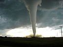
Natural disasters are a grave reminder of how helpless man is against the forces of nature. Tornadoes are just one of the many destructive forces of nature that can uproot you within seconds and throw you around like cardboard chips. Hence, it is important to know and learn about them as much as we can to make sure we are at least better equipped mentally to face the deadly aftermath of this catastrophe.
So what exactly is a tornado?
According to the National Weather Service, a tornado is
“A violently rotating column of air pendant from a thunderstorm cloud and touching the ground”
It is basically a moving column of violent air that is connected with the ground and a cumulonimbus cloud (in most cases) as the same time. In the United States, there are around a 100,000 thunderstorms that form within a year’s’ time; and there are 600 to 1,000 thunderstorms each year that bring tornadoes with them.
Tornadoes can form in almost any state; but the states that are most affected include Texas, South Dakota, Oklahoma, Nebraska, Missouri, Mississippi, Louisiana, Kansas, Iowa, Indiana, Illinois, Georgia, Florida, Arkansas, and Alabama.
So how much do you know about tornadoes? Let’s find out!
These destructive machines of nature are a weather-related event. Normally, a tornado’s path of expected to be around four hundred yards wide and four miles long. But don’t be fooled! Some tornadoes may surprise you with a hundred-mile long path and about a mile wide! They can reach a height of about 60,000 feet – you think the Giant in “Jack and the Beanstalk” would have been that tall or is it just us?
A tornado can move at an average speed of between twenty five and forty miles per hour, but there are some that can chase you at an astounding seventy mile per hour speed. And that’s just the tornado; the winds inside it have a speed of their own – let’s say they can swirl around at almost three hundred miles per hour. There is no way you can beat that!
If we observe the average stay of a tornado on the ground, it is hardly ever more than an interval of about five minutes, but the tornado keeps returning to the ground, and the touchdown could be several times in a row!
So which direction do these tornadoes move in? Allow us to enlighten you.
These tornadoes really have a strong sense of direction – we mean, how else would the tornadoes rotate clockwise in the southern hemisphere and counterclockwise in the northern hemisphere? Also most tornadoes are founding moving to the northeast from the southwest.
Another interesting fact about tornadoes is that a majority of them occur in the time span between 3PM and 7PM. Although these tornadoes occur across the globe in many different countries, United States gets the largest share of them, and they’re also the most destructive ones to occur. On an average, the United States faces almost eight hundred tornadoes each year.
Do you know how many people are killed by tornadoes each year?The figure comes around ONE HUNDRED!
Peanut wood is a type of petrified wood which is usually black or brown in color. It got its name from the white to cream markings which are about the same size and shape as peanuts. But before we dive into what peanut wood is and how it is formed, it is important to know what petrified wood is.
Petrified Wood
Every often, wood decomposes. But in the case of petrified wood, something which is commonly known as “wood converted into stone” occurs. When a tree turns into a fossil, it converts to a three-dimensional replacement of the plant. This happens when the actual organic matter of the tree is replaced by a silicate such as Quartz. As a result, it turns out that a tree is preserved in its original shape but changes its state and turns to stone.
Petrified wood is not rare. It is often found in sedimentary rocks or volcanic deposits around the world. It is often sold as gemstone and used as decorative material in households. Like all gem material, petrified wood is also associated with many healing properties.
How is Peanut Wood Different from Normal Petrified Wood?
Though peanut wood is a type of petrified wood, it is different from the normal petrified wood. The peanut wood we know today originated in Western Australia as a conifer tree. Over the years, when the trees died, they were carried away by the rivers into the salty sea.
This can be dated back to the Cretaceous time period. Back then, the sea into which the trees were carried was an epicontinental sea. This sea covered most of the continent which we now know as Australia. Also, during that time, there were marine species of clam which survived on wood. As the wood entered the sea, the tiny clam would swim to it and attach themselves over the piece of wood. As it was a source of food, these tiny clams would use their sharp edges of their shell to shave off small particles of wood. Within a few weeks, they could dig many deep tunnels into the wood.
As the tunnels were dug in the tree trunk, it would sink down to the sea floor. Apart from the wood eating clams, other species also survived in the water back in the prehistoric times. One particular species which aided in the formation of peanut wood was radiolarians. These are tiny plankton with siliceous shells which lived above the wood in the water. They generally thrive near the river mouth as they receive a continuous supply of nutrients. As the wood is brought to the sea, the radiolarians continue to live on the wood. But when they die, they usually sink in the water. Since their shells are made up of siliceous elements, they accumulate as a whole sediment.
Deep at the seafloor, there is wood with deep tunnels. Layer after layer, the white sediment from the dead radiolarian accumulates over the wood. Overtime, it enters the holes in the wood log Since the shells are siliceous, some of them get dissolved in the water. This concentrated silica solution enters the cavities of the wood. And then just like normal petrified wood, the organic matter of the tree is replaced with silica. Over a period of time, layers of mud and sand cover the wood and with increasing pressure the process of petrification begins. It is believed that this petrification process occurred around 120 million years ago.
However, peanut wood is different in appearance compared to petrified wood. Unlike normal petrified wood which closely resembles the original tree but is different in texture, peanut wood has white or cream peanut sized markings formed due to radiolarians occupying the bore holes in the tree.
Wood Eating Clams Today
While wood eating clams were common in the Cretaceous period, a few species of wood eating clams still live in the oceans. These wood eating clams are now known as shipworms. These shipworms have posed a threat to wooden boats for quite a long time. As the wooden boat moves around in the sea, these worm-like creatures cling onto the bottom of the boat and create tunnels in the wooden surface. This can cause serious damage especially to smaller wooden boats.
To overcome this problem, shipbuilders started using thin copper sheets to protect their ships from the damage of shipworms. But despite the measures, shipworms continue to cause structural damage to the ship.
How Peanut Wood was Found?
Millions of years ago the process of peanut wood petrification began in the region which we now know as Australia. Back then, the region was covered with sea. The seafloor which contained peanut wood was lithified into sedimentary rocks which were then known as Windalia Radiolarite. As the continental formation changed, these sedimentary rocks rose above the surface of the sea. In these rocks, peanut wood was discovered and classified as a gem material.
As this unique petrified wood was found, it soon became famous due to its distinct appearance. It was then used to make decorative items for households and commercial use.
Today, gem hunters around the world seek to find Windalia Radiolarite. It is widely sold through online auctions and gemstone websites. It is also displayed at gemstone and mineral exhibitions such as Tucson Mineral Shows. Given the easy access, people around the world can buy this surprising and interesting piece of petrified wood.
Conclusion
Peanut wood is a gem material found in the sedimentary rocks called Windalia Radiolarite. It is indeed surprising to see an ancient piece of wood that was bored by clams is now a precious gem material with multiple uses.
An average lightning strike contains 15 million volts of energy.
A single strike can heat the surrounding air to over 50,000 o F.
Around 100 lightning strikes hit the Earth every second. That makes around eight million strikes every day.
Unlike common belief, lightning can strike the same place twice.
The phenomena kills an average of 73 people in the US each year.
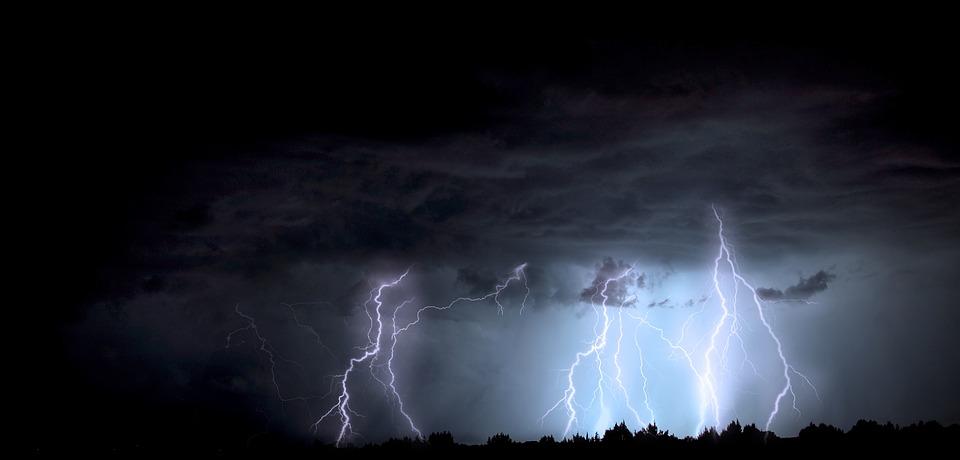
Lightning Strike
Every year, people around the world experience three billion lightning strikes but not all make contact with land. If you look at the numbers, as little as 3% of the total strikes touch the surface of the Earth. When they hit the surface, the temperature of the surrounding air rises to around 50,000 o F at that specific instance. Imagine what it can do to the surface it touches! But on a positive note, the temperature rapidly decreases. Scientists have tried a gazillion times to capture the static charges but have not succeeded so far.
According to some data, every year, around 6,000 people die as a result of lightning strikes. However, National Geographic nullifies the claim and states that not more than 2,000 people die each year.
What is a Lightning Strike and Why Does it Happen?
Lightning is basically an electrical discharge. When there is a thunderstorm, the particles of rain and at times snow particles due to very cold temperatures collide. This friction creates imbalance and in most cases, a negative charge is generated which reaches the lower parts of the cloud. Nature then comes into action to rectify this imbalance.
As a result, we see lightning. From objects on the ground like trees, steeples, even people to different objects from the surface which create positive charges, all can get affected by a lightning strike. When the negative and positive charges come in contact with each other we see a lightning strike.
As mentioned earlier, a lightning strike can be extremely hot. The temperature of the air surrounding the strike can go as high as 50,000 o F. This rapid change in temperature causes the air to expand and Bang! We hear the thunder. Since the speed of sound is lower compared to the speed of light, we can see the lightning strike first, then followed by the sound of thunder.
Types of Lightning
Lightning strikes can be classified according to how they are distributed. They can either be distributed within the clouds or can be between the clouds and the ground. Let’s take a look at each type.
Lightning Within the Clouds
Lightning within the clouds can be further divided into two types.
Intra Cloud Lightning
Intra cloud lightning is the one that happens within just one cloud ball. It generally happens on the outer sides of the cloud. The scenario is the same of negative and positive discharges. But the only difference is it never reaches the ground.
Inter Cloud Lightning
This type of lightning happens when two clouds come in contact with each other. In scientific terms, different areas in the clouds have different charges. Some are positive while others are negative. Lightning happens when negative and positive charges come in contact. This type of lightning is the most commonly occurring type of lightning.
Cloud to Ground Lightning
It is obvious from the name that this is the type of lightning which generates within the clouds but hits the ground. Though it is the least common type of lightning, this is definitely the deadliest form of lightning witnessed by humans on this planet.
A stepped leader or the negatively charged initiator descends from the top of the cloud. Along the way, more negative charges gather. But when it hits the surface, it results in a major disaster.
Another way of defining lightning is through the shapes.
Sheet Lightning
When a lightning strike occurs in just one cloud and lightens up the whole cloud, it is call sheet lightning. It happens mainly in intra cloud lightning. This type of lightning can be very rarely seen in inter cloud lightning.
Heat Lightning
This is the most common type of lightning we all witness. When lightning occurs in the sky within different clouds which come in contact with each other. As a result of interaction of the positive and negative charges, a lightning strike is created.
Staccato Lightning
Staccato lightning is a type of lightning which occurs for a very short and brief instance. It looks like a straight line with a single flash similar to a camera flash. On its way down to the surface of the Earth, it also reveals some of its branches. This happens in cloud to ground lightning.
Forked Lightning
This is also a type of cloud to ground lightning. It is a very simple lightning which has branches and all the branches touch base with the surface but the origin is the same charge.
Ribbon Lightning
This type of lightning is most common during thunderstorms. When the wind is moving fast and with cross winds when the charges come in contact, the process of lightning starts. This causes multiple strikes to hit the surface of the ground, with every strike right next to the other in the direction of the wind. Obviously this again happens during cloud to ground lightning.
Bead Lightning
This is one of the rarest types of lightning. When lightning breaks into different parts and strikes different sections in the same area with no fixed patterns, the system is called bead lightning.
There are a few more types but they are not commonly known and are very rare. In the final section, we will look into the biggest lightning disaster in history.
The Biggest Disaster Due To Lightning
The biggest disaster due to lightning happened during the times of the French dictator Napoleon Bonaparte.
As the dictator took over a small European country named Luxembourg in the early 1800s, he converted it into his backyard to store arms and ammunition. He constructed a number of bunkers and underground warehouses to stock his weapons and supplies.
On June 26th 1807, a lightning strike at one of his gunpowder factories in Luxemburg, one of the smallest countries in Europe. This factory was built in a fortress in the southern part of the country in the city of Kirchberg. The fortress was constructed in 1732 and was now being used as an armory to refill the Napoleon forces in the southern part of the country.
Subsequently the factory exploded and immediately killed approximately 300 people in the very same instance. The ammunition depot was destroyed along with the gunpowder factory. 2 blocks of the castle were destroyed, leaving everything living, dead. Several other areas nearby were also burnt and huge quantities of armor were also destroyed. So it can be concluded that what appears to be Nature’s lightning show is something which can be extremely dangerous and deadly.
Generally, lakes are considered to be a source of fresh water. How fresh is your water? Or more specifically, for the benefit of this article, how fresh is lake water?
All water is measured by a scale called ‘pH’, which determines how much of a unit of water is acidic and the acidity rating (pH) is determined by how much hydrogen is in that unit of water.
There is no indication that a reasonable amount of acidic water is bad for you however; indeed, it may have a number of benefits, including being used as a disinfectant and in this world of coronavirus, it may be advantageous to help keep your house and food clean.
The pH range goes from 0 to 14, with 7 being neutral (no acidic content), so pHs of less than 7 indicate acidity. But that does not always mean that water everywhere around the world has a pH of seven. Instead, the pH level in many lakes and rivers are between six and nine.
But there are certain water systems where the pH of water is less than five. This means that they are acidic and this can be a result of various reasons, but mainly, one can classify them into two main causes.
The first reason will be the presence of acids in the water or there has been an inflow of acids from some external sources. This occurs when acidic industrial waste is dumped into the rivers and lakes which eventually increases the acidity of the water. Another external source would be acid rain in the region.
The second reason is simpler. There is a lack of alkaline bases in the water stream.
Acid lakes are often located near areas of granitic bedrocks, siliceous bedrocks and active volcanoes. Certain areas which are marked by researchers as areas which receive acid rain are also some of the common sites of acid lakes. The eastern parts of the US are considered to be areas that receive a high content of acid rain which disturbs the natural alkaline balance in the lakes.
Acid Lakes Around the World
Some of these lakes are so acidic that the water is strong enough to dissolve a person’s skin. But one of the largest acid lakes is located in Indonesia. Unlike other acid lakes, this lake has turquoise waters that appear to be calm and serene but are actually highly acidic.
Ijen Volcano, Java
This volcano complex is located on the border between Banyuwangi regency and Bondowoso regency of East Java. The Gunung Merapi is the highest point of that complex. This name means mountain of fire in the local language. Among this volcano complex is the Kawah Ijen volcano which is a famous tourist attraction. The reason for it being famous is the electric blue glow that comes out of it. The reason for this is the constant sulfuric gas which is present in the volcano. When the gas comes in contact with oxygen in the air, a stunning blue glow is produced.
Apart from the blue glows, the most important thing which the crater is known for is the world’s largest acid lake it holds. The lake is turquoise in color. It has a yellow tinge to it that makes it even more beautiful. This yellow is basically due to the presence of high sulfur content. On the pH scale, the pH of water in this lake is as low as 0.3 which means it is extremely acidic. You can compare the acidity of this water by the fact that lemon juice has a pH of 2 whereas the pH of water of a car battery is 1.
It is a crater lake inside around a 12 miles crater in East Java. It lies between the Ijen Volcano Complex which is a group of stratovolcanoes with a long history. The lake around the crater is around 600 feet deep and holds around 1,130 cubic feet of turquoise water. Due to the high acidity of the water, the water is not suitable for drinking purposes and has a pungent, bitter taste.
However, the lake remains a famous tourist attraction. Though one cannot swim in it, tourists often visit this place to watch the 15 natural waterfalls which connect with this lake and there is a cruise also allows tourists to take a tour of the lake and connecting rivers. However, it is extremely important to take precautions as you cruise through the lake. The high acidity can cause severe allergic reactions on the skin and eyes. In some cases, it can also result in respiratory issues.
The extreme acidity has affected the nearby river water including river Banyu Pahit. When the water from this lake joins the Banyupahit River, it changes the pH level. According to research done in 2017, it is in a bracket of 2.5 and 3.5 pH on average. There is also a high amount of metal particles such as iron and aluminum. Though the river water is less acidic compared to the lake, it is still not safe for human consumption without treatment.
The government in Indonesia has taken steps to reduce the acidity of the water. They are using techniques such as filtration and reverse osmosis to increase the pH level of the river. This is done to ensure that the negative impact of acidic water can be minimized.
As mentioned earlier, the reason for the high acidity of this lake is the presence of high sulfur content. This sulfur provides a source of income to the local population. In fact, most of the locals are associated with sulfur mining.
Conclusion
There are many other acid lakes spread throughout the world but Ijen volcano Crater Lake is the most acidic lake known on this planet. While the water of the lake is not suitable for irrigation or human consumption, it is a source of employment for hundreds and thousands of people associated with sulfur mining.
Is it possible for some parts of the world to exist below sea level? The answer is yes. Sea level is the average level of the Earth’s surface which is used as a parameter to measure the planet’s elevation. There are multiple locations that have a negative attitude when compared to sea level. In the post below, you will find out about six such locations that are indeed unique.
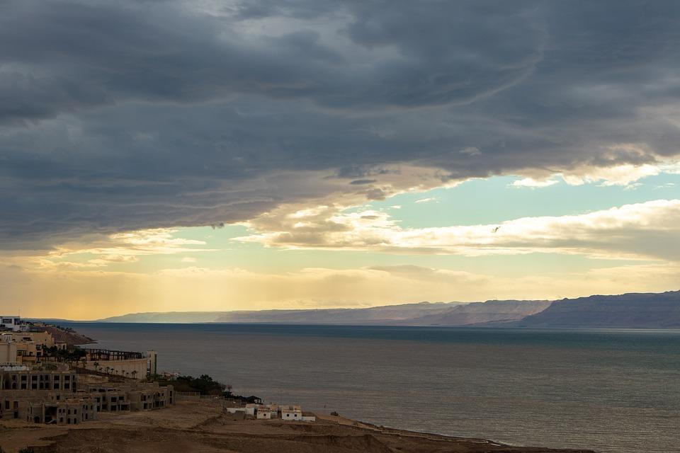
The Dead Sea – Israel, Jordan
The lowest point or the deepest place on Earth is the Dead Sea in the Jordan Rift Valley, bordered by Isreal on the west and Jordan on the east. It is a famous tourist destination where people visit to explore the uniqueness of this sea.
The known depth of this point compared to sea level is almost 1,355 feet (413 meters) however, the parameter can be complicated due to various weather conditions. It depends upon the rate of precipitation and the level of water evaporation from the sea. In case of a drought, when there is limited rainfall and evaporation rate is high, the depth of this lowest point can reach its maximum which is 1,355 feet below sea level. After the rainfall, the depth can be decreased by a few feet.
The distinguishing feature of this coast is the high salt content which forms for the incredibly unique natural landscape. The high concentration of salt attracts tourists due to health reasons. It is believed that salt water can cure numerous diseases and conditions of the skin.
The reason for excessive salt concentration in this sea is the presence of salt rocks during the oceanic water. Due to higher levels of evaporation of the water from the sea, the salt rocks are exposed even at the coast. Also, these salt rocks are the reason for the formation of natural landscapes and sculptures. So tourists who visit this place not only enjoy the unique formations but also benefit from the assumed healing properties of the water from this deepest point on Earth.
Lake Assal, Djibouti
The second-lowest point is the Lake Assal in Djibouti. An East African country located in the Horn of Africa on the Gulf of Aden. It is situated at the bottom of a crater lake which is almost 509 feet (155 meters) below sea level.
This lake is a part of the larger region known as the Afar depression which extends well into Ethiopia. It was described by National Geographic as the cruelest place on Earth due to extreme climatic conditions. Similar to most other lowest points, Lake Assal is characterized by high temperatures, desert and a volcanic landscape.
The Turfan Depression
The third lowest point below sea level is Turfan Depression, a location in China with a depth of 505 feet (154 meters). This, however, is the average depth of the area and the exact depth varies with climatic conditions. Despite the hot and dry climate, there is a salt lake at the bottom of this depression. In the northern part of this depression is a small oasis city known as Turfan.
Based on the archaeological research, it is believed that the area was inhabited by humans in the 10th century. Today, this is an important historical site for tourists who can enjoy the remains of the early civilization along with the evidence of the last volcanic eruption in the 12th century. It is also believed that the high level of volcanic activity over the number of years has also contributed towards the formation of this depression.
This depression also experiences the similar weather conditions as the Lake Assal. The summers are hot and dry and temperatures in the region can spike up to 104 oF. During the summers, this deepest point in South Asia and China is always dry so is the salt water lake at the bottom of this depression.
Qattara Depression
Another deepest lowland is again found in the African continent. With a depression of 436 feet (133 meters) below the sea level, the Qattara Depression forms one of the lowest points in Africa. After extensive research of this region, the archeologists believe that the region was never inhabited due to the extreme weather conditions and lack of water. The average annual rainfall in the region is as low as 2.1 inch. During summers, the temperature can rise as high as 97 oF. The extensive heat and lack of rainfall results in the prevention of water basins however, the distinguishing feature despite high temperatures in the breeze which does not stop at any time of the year. Today, only a few nomads can be found in the region.
Caspian Depression, Kazakhstan
The largest enclosed body of water in the world is the Caspian Sea which is also one of the lowest points below sea level. The shore of this depression is almost 92 feet (28 meters) below sea level. The sea strands its borders with countries of the U.S.S.R region including Azerbaijan, Turkmenistan, Russia and Iran. Unlike its name Caspian Sea, the Caspian Sea is not a sea or part of the ocean but is a salt water lake with no natural outflow. This lowland depression includes the Northern Part of the Caspian Sea.
Danakil Valley
Another lowland in Africa is the Danakil Valley. It is located in Ethiopia and is referred to as Danakil desert. The valley is unique because it is located at the border of the three large tectonic plates including the African plate, the Indian Plate and the Arabic Plate. This valley is considered to be one of the most dangerous places in the world. This is not only due to extreme temperature and weather conditions but also due to the poisonous landscapes. The valley is known for its constant volcanic eruptions which are accompanied with sulfurous water. Together, it forms a dangerous landscape releasing toxic fumes that too at a depth of 410 feet below sea level.
This extremely hot and dangerous valley was not known until 1928 when a group of travelers first identified this location. This group of travelers which was led by Tullio Pastori managed to cross the valley on foot. To date, no other group of travelers have managed to accomplish this. As of now, this valley is a tourist destination but only for those courageous enough to survive in extreme conditions. It is here that you can witness the continuous eruptions of lava which have been spreading since many years.
Conclusion
Lands below the sea level not only have a unique landscape but also have distinct weather conditions which are much different from that on the surfaces at sea level. There are many other lowlands of Earth. Some of the most famous ones not included in this list are the Death Valley and the Salton Trough.
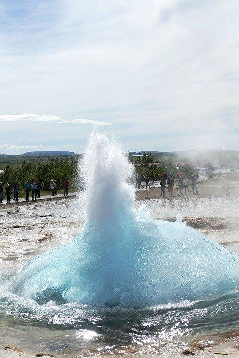
A geyser is a vertical column that periodically erupts hot water and steam. This amazing phenomenon that blasts water from beneath the surface of the Earth is a truly rare sight.
For those who are unaware of what a geyser is, it is a geological feature similar to a tube that runs deep into the Earth’s crust. This tube is often filled with water, but the heat comes from the molten rocks at the bottom of it. The molten rocks called magma heat the water in the tube to a point where the water starts boiling and turns into steam. Since the space is limited, the steam is pressurized. As a result, we can see boiling water and steam erupting from the tube called a geyser.
There were numerous active geysers around the world. However, in the last century, we have seen a decrease in the number of them. Currently, there are only five countries in the world that have them.
The United States
Russia
New Zealand
Iceland
Chile
Despite their geographical distance, there is one thing which is common in all five countries; they are all located in regions with recent volcanic activity and are near the tectonic plates. While every geyser functions in the same way, they are not all the same. Below you will find out about some of the famous geysers around the world and what makes them special.
Geysir
Iceland is a country with numerous islands, active volcanoes and yes, geysers. The Great Geyser, also known as Geysir, is the most primitive geyser known to date. It can be dated back to around 10,000 years ago The first printed document about the geyser was recorded in 1294. Even the name geyser comes from a native word “geysa” which means hot springs.
The steam plume can fire up to eight times a day and can reach a height of more than 200 feet. The super-heated lava in the region melts the ice which is present in the region throughout the year. As a result, there is an increasing number of active geysers in the region. A critical fact about geysers is that they can become active and inactive suddenly due to changes in the geothermal activity taking place below the surface of the Earth. This was also the case with Geysir, which stopped erupting in 1932 and started again after the earthquake of 2000.
Old Faithful
Located in Yellowstone National Park , this is probably the oldest and most famous geyser on the Earth. As the name suggests, it has been continuously erupting regularly, hence it has been named faithful. The old geyser has been erupting for the past 30 years and erupts 23 times every day. But the height of eruptions is comparable to some of the other taller geysers in the world. The eruptions can reach from 100 to 180 feet in height.
Old Faithful is a classic example of a cone geyser. This type of geyser produces a constant, vertical column of water where water shoots up from its opening.
Grand Geyser, Yellowstone National Park
Yellowstone National Park has one of the most active geyser basins in the world. The reason is its proximity to the mid-Atlantic ridge. This means they are located at the intersection of two tectonic plates – the North American plate and the Eurasian plate. These plates are at the moment moving away from each other at a rate of three-millimeters per annum. This movement releases energy which is causing hot, molten lava to flow out. As a result, there are more active volcanoes and geysers in the region.
Moreover, the Yellowstone National Park is on top of Yellowstone Super Volcano Caldera in northwestern Wyoming and southeastern Montana. The grand geyser is located in the southern part of the park just 160 feet north of a more frequently erupting called Strokker geyser. It is a fountain geyser and is the tallest predictable geyser known to date. It reaches a maximum height of 200 feet. Each eruption lasts for 9 to 12 minutes after which the pool becomes dry and refilling time is 5 to 6 hours. Hence the eruption takes place 1 to 4 times a day.
Strokkur Geyser, Iceland
Stokkur geyser is located around 160 feet south of the Great Geyser in Iceland in the Haukadalur valley area. This area also has mud pools, fumar holes and other geysers. It is a very sensitive geothermal location. Strokkur is a native word in Iceland which means to churn. Strokkur geyser is known for its rapid eruptions which can be seen after every five to ten minutes.
Each eruption lasts for approximately two minutes. The usual height of the geyser is around 50 feet. However, when the first eruptions were noticed in 1789, they were as high as approximately 200 feet. Later in 1896, the geyser became inactive due to an earthquake which blocked the steam flow. It became active again through human efforts in 1963 when the geyser committee of Iceland advised the locals and the blockage was removed. It has been active ever since. It is again one of the very few reliable geysers which have been erupting very regularly.
Waimangu Geyser, New Zealand
Let’s not forget the Waimangu Geyser which was the tallest geyser in the world. The eruptions from this geyser have reached a height of around 1,500 feet above the ground level. Such was the power of Waimangu geyser.
The first eruptions were noticed as early as in 1901. The cycle of the geyser was around 36 hours. These eruptions lasted for five to six hours and were a popular tourist destination. However, in 1904 the geyser started to lose its power and eventually became inactive after a landslide in the area, though research proves that there is no connection between the two. The geyser stopped erupting on November 1st, 1904, and became extinct in 1908. After this, the hydrothermal activity in the region increased, especially in the nearby Echo crater, eventually leading to the volcanic eruptions in 1915, 1917 and 1924.
According to research, the early eruptions started because of the Great Mount Tarawera volcanic eruption in 1886. The water during the early eruptions from the geyser was muddy and black with stones of the surrounding terrain. Hence the name Waimangu was given which means black water in the native language.
The great lakes in the continent of North America make up the world’s largest body of fresh water on the planet. The Great Lakes account for 1/5th of the freshwater surface on Earth. They include five freshwater lakes that lie in separate basins but are naturally interconnected. The Great Lakes include
Lakes Superior
Lake Michigan
Lake Hu ron
Lake Erie
Lake Ontario
These fresh water lakes lie in the upper Middle Eastern part of the United States towards the Canadian border and stretch far into Canada. They touch the Atlantic Ocean through the Saint Lawrence River and touch multiple cities and states ranging from Ontario, Michigan, Wisconsin, Minnesota, Illinois, Indiana, Ohio, Pennsylvania and New York.
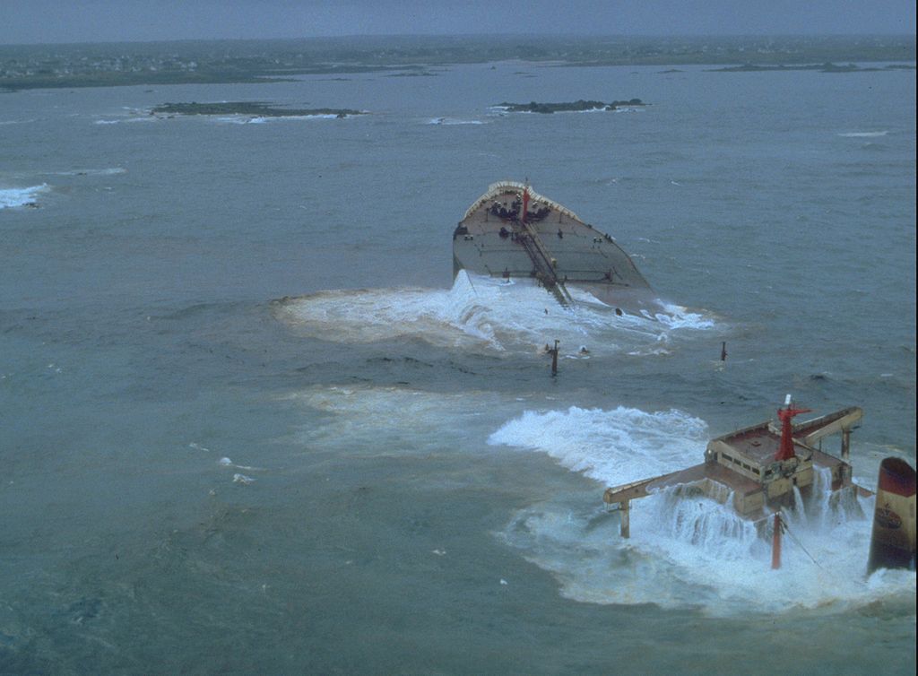
There are more than 35,000 islands on these lake. There is an approximate 1% change in the volume of water due to discharge and incomings. This is also due to the rain water and evaporation from the Great Lake. The human consumption of fresh water has not significantly affected the volume in the system. But like any water system, the Great Lakes also experience rainy days and that can have severe implications. There is evidence of accidents due to severe weather conditions such as when a frigate in 1975 that was transporting cargo sank and 29 of the crew members died with it. In rough weather, it is very difficult to navigate in the lake due to the very sharp and shallow routes.
These lakes are also called the fourth seacoast in the United States. According to statistics, more than 30 million people were living in the lake’s basin in 2017. This accounts for 10% of the US and 30% of the Canadian population.
Geology of the Great Lakes
The Great Lakes of North America were not always fresh water lakes. Around 14,000 years ago, this part of the world was covered with a massive glacier which was about half a mile thick. Overtime, as the glacier melted, it continued to move towards Canada and as it moved, it left behind a series of depressions which were filled with water. Around 10,000 years ago, the glacier transformed into something similar to the Great Lakes as we now know them.
Until around the early 19th century, it was believed that the Great Lakes were the largest freshwater lakes in the world. However, this perception changed as more lakes were discovered around the world. As far as the area is concerned, The Great Lakes in totality that is all the five lakes combined are the largest freshwater lakes by area but they are the second largest lake by volume of water stored. The largest lake by volume is Lake Baikal in Russia on the Siberian front.
The Great Lakes spread over an area of around 95,000 square miles holding a total of 5,439 cubic miles of freshwater. This accounts for almost 21% of the total fresh water by volume on the planet of Earth. On the other hand, Lake Baikal holds 5,666 cubic miles of water which is almost 23% of the total fresh water present on the planet’s surface. Difficult to imagine this volume? It is equivalent to submerging the entire North American continent under 5 feet of water!
Due to physical characteristics of the sea i.e. the winds, strong currents, waves, depths, the Great Lakes are also referred to as inland seas. Some of the highlights of these Great Lakes include Lake Superior being the single second largest lake by area after Lake Baikal. Also, Lake Michigan is the largest lake in a single country that is the United States. In the nearby region, there is another lake as well which is called Lake Megapolis.
Facts about the Five Great Lakes
Let’s take a quick view of some facts about each of the five Great Lakes.
Lake Superior
Lake Superior covers an area of 31.699 square miles and ranks second in the list of world’s largest freshwater lakes according to area covered. If you look at the volume, Lake Superior is in the 4th position in the world holding 2,903 cubic miles of water.
It takes its name superior from a French word lac supérieur which means upper lake as it lies north of Lake Huron.
Lake Michigan
Lake Michigan covers an area of 22,300 square miles and ranks 5th in the list of world’s largest lakes according to area. But when it comes to the Great Lakes, it is only the third largest of all 5 lakes. According to the volume of water that it holds, lake Michigan is in the 6th position in the world with 1,180 cubic miles of water.
Lake Huron
It is the second largest of the 5 Great Lakes covering an area of 23,000 square miles and ranks fourth on the list of world’s largest lakes according to area. By volume, Lake Huron takes the 7th position in the world holding almost 850 cubic miles of water.
Lake Erie
On the list of the 5 Great Lakes, Lake Erie ranks 4th. With an area of 9,910 square miles, it ranks 11th on the list of world’s largest lakes according to area covered. According to the volume of water that it holds, Lake Erie is in the 15th position in the world holding 116 cubic miles of water.
Lake Ontario
This is the smallest of all 5 lakes. Lake Ontario covers an area of 7,340 square miles and ranks 14th in the list of world’s largest lakes according to area. If you look at the volume of water it holds, Lake Ontario holds 393 cubic miles of water and ranks 11th in the world.
The Great Lakes and the Economy
The Great Lakes are a major source of fishing, trade, transportation and migration of birds in North America. More than 3,500 species of plants, birds and animals inhabit the lakes. These lakes are home to 170 different types of fish and sea animals.
Moreover, the lake experiences different bird seasons. And since the Lakes connect the United States and Canada, they offer a major transportation route between both countries. Not to forget these lakes are a tourist’s heaven.
Since there are many islands, some of them have been converted into resorts and recreational parks. Hence every year both countries enjoy tourist revenue from these magnificent bodies of water. Unfortunately, like all tourist destinations, pollution is becoming an increasingly common problem. Both the US and the Canadian governments need to take strict measures before humans contaminate the lakes to a point of no return.
A maar is a landform formed by volcanic explosive ash eruptions (Pixaby)
Maar is a shallow depression (also known as a volcanic crater) with steep sides and is one of the most common volcanic landforms found on Earth. It is formed when the hot magma inside the surface of the Earth is ready to explode. But along the way, it comes in contact with groundwater. As a result of boiling lava colliding with water, there is a massive steam explosion and consequently, the rocks are ejected far into the air along with steam and ashes of the magma. As molten lava reacts with cool water, the resulting steam explosion creates a depression that eventually gets filled with water. The result is the creation of a landform similar to a crater. The difference is that craters are usually below the original surface of the ground.
Very often, as the rocks above the ground water are shattered and the water usually reaches the surface of the Earth resulting in a shallow lake. As the rocks land back on the surface, they form a tephra which surrounds the crater and forms steep edges.
Usually, maars are formed when there are multiple explosions at different depths. So after an initial explosion, when water finds its way up to the newly formed crater, it provides fuel for additional steam explosions.
Biggest Maar on Earth
Typically, maars range from a few hundred to a thousand feet in diameter and they are often less than 300 feet in depth. But the average width of most maars is about 1,000 feet. The size of the maar is limited because the lava does not erupt. Instead it collides with water and the reaction immediately stops. While the average size of maars is mentioned above, there are a few which are much larger than average. Let’s take a look at some of the biggest maars on the planet.
The Devil Mountain Lakes
The largest known maar on Earth is the Devil Mountain Maar Lake in the northern part of the Seward Peninsula of Alaska. It is a result of a volcanic eruption which reacted with water around 17,500 years ago. The resulting explosion affected an area of around 950 square miles. The maar which was formed as a result of this reaction is almost five miles wide and 3.7 miles deep.
The resulting tephra which was formed is several feet thick. As it moves farther away from the maar, the thickness of the tephra decreases.
The Devil Mountain Maar Lake is unique because it was formed as a result of a complex reaction between the molten lava and ground water at different depths. This complicated reaction is the reason for the unusual size of the maar.
North and South Killeak Maar
The North and South Killeak maars, also located in Alaska are two distinct maars in the same region. The South Killeak maar is considered to be around 40,000 years old. This is a huge maar which is more than three miles long is around 200 feet deep.
The maar on the Northern side is slightly older and is considered to have an age of 50,000 years. However, it is slightly smaller than the South Killeak maar. This maar measures 2.5 miles in length and is around 80 feet deep.
Whitefish Maar
The oldest, yet the smallest among the three largest maars is the Whitefish Maar, also in Alaska. It is estimated that this land mass was formed between 100,000 and 200,000 years ago. With a length of almost 2.5 miles and unidentified depth, the Whitefish maar remains one of the largest known maars on the planet.
Evidence of Maar on Mars
While maars are a significant landform on Earth, there is evidence that these landforms exist on the planet Mars as well. Scientists and researchers around the world have a special interest in the Red Planet due to its similarities with Earth. They have managed to find evidence of a similar reaction taking place between molten lava and ground water at several places. So far research indicates that the maars on Mars are relatively smaller compared to those on Earth. Also according to research, the resulting maars are due to one or two explosions resulting from a reaction between water and molten lava.
Significance of Maars on Mars
The evidence of maars on Mars is an extremely important discovery. It indicates that the reaction is taking place very close to the surface. There is evidence that the molten lava and water reacts just around 1.5 miles under the surface of the planet. This means that discovery of the materials resulting in the formation of a maar is relatively easy.
But the evidence of a Martian maars is significant because it indicates the presence of water. Since water is an essential ingredient of life and also is an ingredient of the formation of a maar, there is a promising indication that there may be the presence of water on the Red Planet.
Another reason why the discovery of Martian maars is so important is that there is evidence of fossils on Mars as well. This can play a critical role in finding out if martian life once existed on the planet.
Conclusion
There are many unique processes which are constantly taking place under the surface of the Earth but we only get to know about them if we find evidence on the land. Maars are a result of such hidden entities. The discovery of this phenomena taking place on Mars is an indication of the possibility of life on the Red Planet; something we are all eagerly waiting to find out.
Undoubtedly the most famous oil spill in the recent era is the Deepwater Horizon in 2010. The spill killed 11 workers and thousands of marine species. The clean-up cost for British Petroleum was $65 billion. But was this really the largest oil spill in history?
Not really.
Not all oil spills are the same. There are several types of which can affect the land and water in multiple ways but for better-understanding oil spills around the world can be divided into three categories.
Tanker accidents
Acts of war
Out of control oil wells
Though out of control oil wells are not a common phenomenon, they are responsible for some of the largest spills in history. However, so far tanker accidents are the most common category of oil spills and account for the loss of over one million barrels of oil. Let’s take a look at some of the largest oil spills.
The Amoco Cadiz Oil Spill – 1978
On the morning of March 16, 1978, Amoco Cadiz, an oil tanker was navigating through the rough sea of the English Channel. A big wave struck the rudder and the hydraulic system. The ship ran aground on the very sharp rocks on the island of Brittany in France at around 6:00 AM. Since the sea conditions were adverse, it was almost impossible for the rescue workers to do anything about the spill. Even the rescue toe lines couldn’t last for a few hours. The shallow underwater rocks on the island finally damaged the hull and the leakage from the tanker began.
From there onwards, over the next few days, more than 1.6 million barrels of oil spilled into the sea and spread over more than 200 miles along the French coast. The spillage killed millions of sea inhabitants and thousands of birds and contaminated the oyster bed in the region. The Amoco Corporation, the owners of Cadiz, agreed to pay $155 million as a claimant in the incident.
The Atlantic Empress – 1979
Atlantic Empress, which was in service for more than five years, collided with Aegean Captain on July 19th, 1979. The collision occurred on the coast of Trinidad and Tobago. During a tropical storm, both the ships couldn’t do much as the ships came on to a collision path and finally collided.
This became one of the worst disasters the oil shipping industry has ever faced at that time. Around 2.13 million barrels of oil spilled into the sea. Both the ships caught fire as a result of the collision but the response action was pretty quick. Rescue workers towed the burning Atlantic Empress to open waters where it burnt for several days and finally sank.
On the other hand, the Aegean Captain was towed towards the coast as the fire was controlled and the ship sustained minimum damages. Regardless of the fact that so much oil was spilled, there was minimal damages to the beaches and sea inhabitants as the wind directed most of the oil away from the shores and the oil very quickly dispersed. However, 27 sailors lost their lives. The estimated loss of oil from this accident was approximately 88.3 million gallons.
Ixtoc 1 Oil Well – 1979
The Ixtox well is located around 50 miles NorthWest of Ciudad del Carmen Gulf of Mexico. The well at the time of the accident was operated by Pemex, a Mexican government owned oil drilling company. It is estimated the oil spill during the process was estimated to be 3.3 million barrels.
It all started in June 1979 when Ixtoc 1 oil well which was exploring oil at 50 meters in the water exploded. Subsequently, the platform collapsed and damaged the valves of the rig. This made it very difficult to close the rig and finally, the rig was sealed after nine months of rigorous hard work by the workers.
The reason for the incident according to the experts was the drilling mud which failed to circulate, resulting in oil and gas pressure building up in the pipes. Operators tried to plug the hole but natural gas went up and by-passed the blowout preventer valve. As a result, it came in contact with motors up on the rig platform which eventually exploded leading to fire.
According to the experts, if the blow out protector valve had worked adequately and released the gas in the open air, the incident could have been avoided.
Over the course of the next nine months, the oil continued to pollute the beaches in the Western Yucatan Peninsula in southern Texas. This resulted in a loss of marine life. The tourism industry in the region also suffered.
BP’s Deepwater Horizon Oil Spill – 2010
The most known oil spill of recent times is the BP Deepwater horizon. This accident also occurred in the Gulf of Mexico which is considered to be the hub of oil and natural gas.
On April 20th, 2010 at around 3:00 PM, a pocket of natural gas blasted all the way up through the Cement well cap which was installed on April 8th of the same year. Subsequently the gas travelled up to the rigs and the platform was ignited as a result.
This immediately resulted in severe devastation on the site. The platform could not sustain the damages and two days later it sank in the water. This accident was a result of an error in BP’s engineering judgment. Due to this mishap, the company had to pay an amount of $65 billion in compensation.
To date, this remains the largest accidental oil spill. The well was finally capped on September 17th the same year, almost five months from the day of the explosion. The amount of oil lost as a result of this accident is still not confirmed. According to the most accurate estimates, 4.9 million barrels of oil were lost. By the time, the well was capped, around 1,300 miles of the US Gulf Coast ranging from Texas to Florida was covered with oil.
The accident resulted in the death of 11 individuals and left 17 injured. The loss was not restricted to human lives, but the marine species also suffered severely. Around 800,000 birds were killed as a result of this spill including a brown pelican which was recently delisted from the list of endangered species. Also, 6,500 turtles died.
There are many other oil spills, but these four mentioned ones remain the largest oil spills in the world.
A salt dome is a geological formation deep under the surface of the Earth. It is a vertical column of salt which protrudes upwards into the layer of sediments called the caprock. Salt formations are typically horizontal, but when in a sedimentary basin where a thick layer of salt is covered by a layer of sediments of heavy mineral, salt formations can rise vertically.
How is Salt Domes Formed?
A phenomenon known as diapirism takes place beneath the surface of the Earth. It allows lighter material to force its way upwards through denser material. In the case of a salt dome, salt has a lower density compared to the rocks above it. When a gravitational force, tectonic force, and a combination of various other forces act upon salt, this results in the deformation of salt. As a result, the salt flows upwards like a viscous liquid.
For the formation of a salt dome, the pressure on the salt must be high enough to allow the salt to penetrate through the layer of sediment above it. Once the salt begins to flow, the process will continue as long as the pressure on the salt is more than the forces acting against it, but once the forces are in equilibrium, the flow of salt will stop.
When conditions are favorable, salt domes can grow thousands of feet above their core. They can also reach the surface of the Earth and result in the formation of salt glaciers. The formation of salt domes does not occur overnight. It is a long process which can take centuries. The process begins in an isolated marine inlet. When the water evaporates, it leaves concentrated salt. Geologists believe that the evaporation process should occur multiple times. This will help achieve the required concentration of salt essential for creating a salt dome.
Once the large deposits of salt are created, wind and other external forces will come into play. Over time, sediments are deposited on the salt. Once the sediments have completely covered the salt formation, the forces acting on the salt will become stronger. Since salt is a mineral with lighter density, it will find its way upwards through the sediments.
Size of the Salt Domes
Salt domes are often very large structures. The diameter of the salt dome can range from ½ a mile to over five miles. The origin or the parent rock from which the salt dome rises is typically found thousands of feet below the surface. A typical salt dome rises at least a mile from its origin and some are known to be higher than six miles.
Economic Significance of Salt Domes
Salt domes are important due to various reasons. They serve as a reservoir for oil and gas. They are also a critical source for sulfur and salt. Once the salt is extracted, the remaining salt dome holes can be used as an effective underground storage and waste disposal site for hazardous waste.
Oil and Gas Reservoirs
Salt domes have a unique significance in the oil and gas industry. As the salt is rising vertically, it exerts pressure on the rocks above it. The caprock, which is the layer of sediment above the salt, is arched upwards. This upward arch serves as a structural trap and can reserve oil and gas. As the caprock is arched upwards, oil and gas migrate towards the salt dome. Salt is an effective trap rock as oil can come to rest up along the salt.
This upward arching of the rock and collection of oil and gas in the arch allows better flow rates of hydrocarbons. This helps in the extraction and recovery of fossil fuels trapped along the salt dunes. The extraction of hydrocarbons along the salt dunes is more cost-effective and environmentally friendly compared to conventional drilling. A single salt dome can have numerous reservoirs of oil and gas at various depths and locations around the salt dome.
A Source of Salt and Sulfur
Since salt domes are salt formations, they can be exploited through mining. Salt is used as an essential raw material in numerous industries. It is widely used in the chemical industry and for treating snow-covered highways. Apart from commercial use, salt also has domestic applications as well.
Another important mineral that can be recovered from salt domes is sulfur. Sulfur is not a part of the salt dome but an important component of the caprock. It occurs as a crystalline material and is known to be formed as a result of bacterial activity. The caprock of certain salt domes contains enough sulfur that can be recovered economically.
The process of recovering sulfur from salt dome involving drilling a well and treating the rock with superheated water and air. However, as of now, this method of recovering sulfur is not cost-effective. Therefore most of the sulfur which is produced today is a byproduct of refining hydrocarbons.
Underground Storage and Waste Disposal
When the salt, sulfur and hydrocarbons are extracted, this leaves large holes which can be used for underground storage. Some of the mines which are developed into salt domes are sealed and can be used for the storage of oil and gas. In the US and Russia, salt domes also serve as state reservoirs of helium gas. This is because salt is the only type of rock that has very low permeability. As a result, it can hold the tiny atoms of helium gas.
Since salt has low levels of permeability, it also restricts the flow of any type of liquid into the soil. These properties make salt domes very effective for the disposal of hazardous radioactive waste.
Conclusion
Salt domes are a distinct geological formation with great economic value. Though it takes centuries to form, once formed, humans can continue to benefit from them for years.